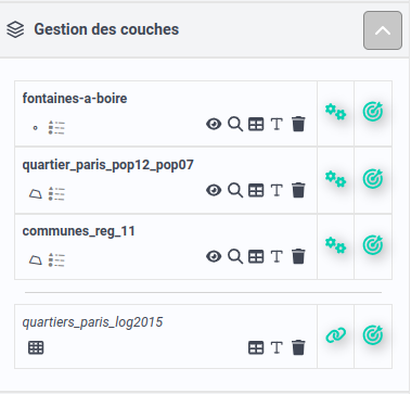
Layer manager
The layer manager is a central element of the Magrit interface. It allows the user to manage the settings of the various layers and tables imported into the application.
 Layer manager
When both a geographical layer and a data table are present into the application, they are separated by an horizontal line in the layer manager.
Geographical layers
Several functions are available for each geographic data layer:
- display a summary of layer information on hover (1),
- display/hide layer legend (2),
- invert layer visibility (visible/invisible) (3),
- zoom on layer (4),
- display the data table associated with the layer (5),
- modify the layer's field typing (6),
- delete the layer (7),
- modify layer properties (8),
- create a new representation](./layer-creation) from the layer (9).
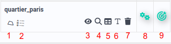 Available functionalities for each layer
In addition, as in GIS or vector graphics software, the layer order in the Layer Manager reflects the order in which the layers are displayed on the map (the layer at the top of the list is displayed above the other layers, etc.).
Data tables
For each data table, you can :
- display summary information about the table,
- join the data to a geographic layer,
- display the data table,
- modify the layer's field typing,
- delete the data table.
In Magrit, tabular data has two main uses:
- to be attached to a geographic layer to create thematic maps,
- be used to create link maps (or flow maps).